Dear all,
I’m working in a QGIS environment (graphical interface). Specifically, I’m using a QGIS modeler. Thanks to the processing toolbar provides, i have access to QGIS, Grass, Saga, and Orfeo toolbox tools algo. My goal is to generate a segmentation for geographic area. For the segmentation, I use the OTB tool via QGIS “Generic region merging”: GenericRegionMerging — Orfeo ToolBox 7.0.0 documentation
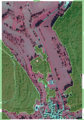
The complexity comes from the fact that I want to contextualize/differentiate the parameters and input data required for the segmentation step,within my study area based on a land use layer/mask layer. So i want to define specific parameters/input data for the segmentation generated on forest areas. And other input data/segmentation parameters generated for non-forest areas (urban, agricultural). I therefore have a vector data set, “Forest DB mask,” which allows me to locate/mask forest areas.
I therefore want to :
- Generate an initial “raster segmentation” from an aerial/satellite image with specific parameters for forest areas (segmentation calculation only for raster pixels that overlap my forest DB mask). Therefore, the calculation must NOT be performed/ be ignored for pixels not covered by this mask layer (agricultural, urban, etc.).
- Then generate a second “raster segmentation” for the rest of the study area that was ignored/skiped during the first segmentation (segmentation calculation only for raster pixels that do not overlap my forest DB mask: agricultural, urban, etc.).
- Then, once these two raster segmentations are complete, the idea is to merge them into a single raster. Then, generate a polygonization (raster to vector).
This little workflow isn’t really complicated. But I’m wondering if it’s possible to do it in a QGIS modeling/graphical interface environment. I’d be interested in advice/ideas. Do I must to clip input rasters with the forest DB masking layer? With a management/assignment of “no data values” to ignore the segmentation processing on areas not covered by the mask layer?
I’ve attached below a screenshot that allows you to display an input raster image (here a multispectral Spot6/7 satellite image) and the mask layer (vector forest DB mask) to better visualize the context
Thanks so much

